Using Google Maps with the house name “Acorns Old Farm” will get you to the door. Using the postcode will not get you here!!
FROM NORTH M5
Leave the M5 at junction 18 (signposted A4 Bristol & Airport). Take the A4 towards Bristol following signs for the airport. Go past Bristol City Football ground and connect with the A38 towards Taunton, the airport is situated 8 miles South of Bristol on the A38. You will approach traffic lights approximately 200m before the airport, there is no right turn allowed at the lights so double back at the airport roundabout, turn left at the traffic lights immediately before The Airport Tavern Pub into Downside Rd. Continue for approx 700m, We are on the right hand side (blue sign Acorns / Old Farm) 50m BEFORE the Airport Emergency & Operations entrance
FROM SOUTH M5
Leave the M5 at Junction 22, at roundabout take 3rd exit signposted A38. At East Brent roundabout joining the A370 take 2nd exit signposted A38 & airport. Continue on this road for approx 11 miles, airport is on the left. Go straight on, heading into Bristol, after approx 150m Turn left at the traffic lights immediately before Airport Tavern Pub into Downside Road. Continue for approx 700m, We are on the right hand side (blue sign Acorns / Old Farm) 50m BEFORE the Airport Emergency & Operations entrance
FROM EAST M4
At Junction 20, join the M5 southbound. Exit the M5 at junction 18 (signposted A4 Bristol & Airport). Take the A4 towards Bristol following signs for the airport. Go past Bristol City Football ground and connect with the A38 towards Taunton, the airport is situated 8 miles South of Bristol on the A38. You will approach traffic lights approximately 200m before the airport, there is no right turn allowed at the lights so double back at the airport roundabout, turn left at the traffic lights immediately before The Airport Tavern Pub into Downside Rd. Continue for approx 700m, We are on the right hand side (blue sign Acorns / Old Farm) 50m BEFORE the Airport Emergency & Operations entrance
FROM SOUTH EAST (BATH)
Follow the A4 towards Bristol, bear left onto the A4174 signposted Ring Road. Continue to follow signs for Airport and A38 Taunton. You will approach traffic lights approximately 200m before the airport, there is no right turn allowed at the lights so double back at the airport roundabout, turn left at the traffic lights immediately before The Airport Tavern Pub into Downside Rd. Continue for approx 700m, We are on the right hand side (blue sign Acorns / Old Farm) 50m BEFORE the Airport Emergency & Operations entrance
FROM SOUTH WALES
Follow M4 over the second Severn Crossing. At junction 22 branch left to join M49 (Signposted South West) and then join M5. Leave the M5 at junction 18 (signposted A4 Bristol & Airport). Take the A4 towards Bristol following signs for the airport. Go past Bristol City Football ground and connect with the A38 towards Taunton, the airport is situated 8 miles South of Bristol on the A38. You will approach traffic lights approximately 200m before the airport, there is no right turn allowed at the lights so double back at the airport roundabout, turn left at the traffic lights immediately before The Airport Tavern Pub into Downside Rd. Continue for approx 700m, We are on the right hand side (blue sign Acorns / Old Farm) 50m BEFORE the Airport Emergency & Operations entrance
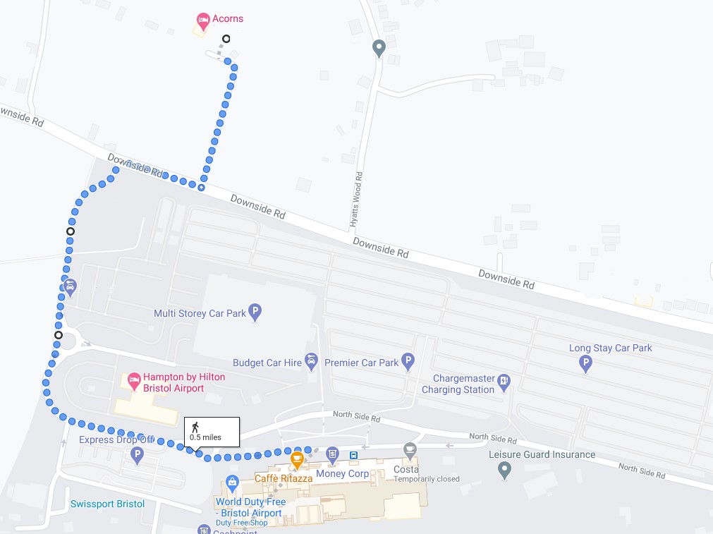
Bewlow is a map to walk to or from the airport